The same satellite offers different answers in different countries
In Thailand, satellites track how durian and mango trees are growing. In Indonesia, they help monitor oil palm yields and forest change. Across the Gulf, they watch over pipelines and energy assets. In Central Asia, they cover vast areas that are difficult to survey on foot.
From its Singapore headquarters, STARPATH GLOBAL has established branches and local teams across Southeast Asia, Central Asia and the Middle East. The company tailors its use of satellite data and AI to each country’s industries and most pressing needs.
One platform, multiple local teams
A software-defined virtual constellation draws on optical, radar (SAR) and hyperspectral data from commercial operators worldwide without requiring a dedicated fleet. The company standardizes and grades the data, then delivers it through one API, contract and service-level agreement.
Local teams use their knowledge of customers and procurement to combine tools for agriculture, forestry, energy and mining around each market’s needs.
Thailand: Orchards, Forests and Islands
The Bangkok branch focuses on three areas:
- An eye in the sky for orchards. Crop monitoring combines multispectral imagery, radar and weather data with crop growth models and AI to track unusual growth patterns, estimate yields across seasons and flag early signs of pests or disease.
- A health check for forests. Satellite observations help assess forest resources and carbon stocks, track changes in vegetation cover and monitor pests, disease and wildfire activity.
- A changing map of coastlines and islands. Comparing satellite images from different dates and tracking changes in water extent reveal how shorelines and island landforms shift over time. These observations support coastal monitoring, conservation and disaster assessment.
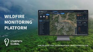 Image: STARPATH GLOBAL’s Wildfire Monitoring Platform
General Manager Roongroj Boontos has over 20 years of experience in enterprise technology and engineering and previously served as a strategic adviser in an advisory office of the Thai Senate. Country Manager Ekasit Suwanlertwattana brings over 25 years of geospatial experience, including work with Thai government agencies. Both are familiar with local procurement and project delivery.
Indonesia: Oil palm, rainforests and minerals
Cloud cover and dispersed sites make radar and optical imagery complementary. The Jakarta team focuses on three areas:
- Oil palm and food security. Long-term plantation and cropland monitoring supports yield estimates, flags unusual plots and informs supply planning.
- Forests and the environment. Tracking vegetation, fire risk and ecosystem conditions supports carbon assessments and environmental monitoring.
- Mining and infrastructure. Hyperspectral data supports mineral mapping. Repeat observations track mine boundaries, extraction and rehabilitation. InSAR can detect millimeter-scale movement at dams and bridges under suitable conditions.
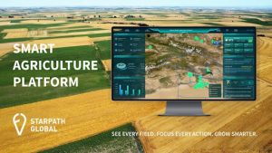 Image: STARPATH GLOBAL’s Smart Agriculture Platform
The team combines agricultural technology and geospatial expertise with over 20 years of telecommunications, enterprise sales and channel development experience. Singapore General Manager Keith Seow previously established a wholly owned subsidiary in Jakarta.
Malaysia: Remote monitoring for energy and industrial assets
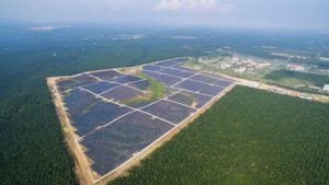
The Kuala Lumpur branch prioritizes energy and enterprise customers, alongside forestry, agriculture and infrastructure. Energy and power monitoring can flag vegetation encroachment, third-party construction and unusual changes around transmission lines, substations, wind farms and solar sites. Change detection and InSAR help operators identify geohazards along pipelines and prioritize field inspections.
 Two local leads each bring over 15 years of experience. One has worked on business development involving major energy companies such as PETRONAS. The other specializes in enterprise digitalization and channel partnerships and has helped a company enter four markets.
Singapore: Southeast Asia’s coordination hub
The headquarters coordinates offices in Bangkok, Jakarta and Kuala Lumpur, develops customer and partner relationships in satellite applications, geospatial services and AI, and shares experience across markets. Seow brings 20 years in regional technology and telecommunications, including responsibility for Indonesia and the Philippines. Business development staff combine aerospace engineering, deployment, data validation and government tender experience with GIS and remote sensing sales expertise.
Kazakhstan and Central Asia: Monitoring across vast distances
Satellite observations can assess crop conditions and yields, survey long pipeline corridors and track activity at dispersed mining sites. The company is developing the market. Vice President Lydia Zhu leads customer and partner outreach and commercial discussions, drawing on around 15 years of cross-border investment experience and a master’s degree in commercial law from the University of Edinburgh and former roles as a UK director at Cushman & Wakefield and head of China at Arada Group.
 Abu Dhabi and Riyadh: Energy, government and data sovereignty
The Abu Dhabi and Riyadh branches focus on government and major energy companies across oil and gas, smart cities and infrastructure. Their approach combines satellite data, geospatial information and AI with sovereign cloud, data and AI capabilities to address security and sovereignty requirements.
Mohammad Abu Sharkh, general manager of the UAE and Saudi Arabia offices, brings over 25 years in digital transformation, AI and cloud. He previously held a vice president role at CORE42 / G42 and has served more than 290 enterprise, federal and defense customers and delivered projects worth over $300 million. The team brings experience serving OQ, PDO and Bapco, along with expertise in localized gas detection. Its smart-city and GIS specialists bring more than 19 years of Middle East experience, including digital twins, Esri tools and government project delivery.
From country-specific strategies to an open ecosystem
The roadmap calls for coordinating the virtual constellation, validating the commercial model and bringing in initial satellite partners and paying customers in 2026. Plans for 2027 include scaling and standardizing the offering, introducing subscriptions and refining industry models. The company plans to open its API to third-party developers in 2028.
Across these markets, one platform and multiple local teams help turn global satellite data into information customers can use to make decisions.
Media Contact
Company Name: STARPATH GLOBAL
Contact Person: Angela Zhu
Email: info@int.starpath.global
City: Singapore
Country: Singapore
Website: https://starpath.global/